Contents
A major fault zone known as the Motagua & Chixoy-Polochic fault complex cuts across Guatemala to form the tectonic boundary between the North American plate and the Caribbean plate. Along Guatemala’s Pacific coastline, we have the Cocos plating pushing against the Caribbean plate, forming the Middle American Trench subduction zone approximately 50 km from the shore. These two are major tectonic processes and they have produced secondary fault zones such as the faults of Mixco, Santa Catarina, and Japatagua.
With all this in mind, it comes as no surprise that Guatemala is prone to earthquakes – big and small. Some of the low-magnitude earthquakes in Guatemala are so shallow that they still cause major destruction, although only in a very limited zone. The 1985 Uspantán earthquake was for instance only a 5.0 Mw shake, but still destroyed most buildings in the town Uspantán while leaving the rest of Guatemala unharmed. It was a very shallow earthquake with a depth of just 5 km.
Below, you will find a few examples of notable Guatemalan earthquakes.
The 1717 Guatemala Earthquake
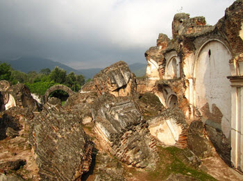 This earthquake took place on 29 September local time and caused widespread destruction in the colonial capital of Central America, the city we today know as Antigua Guatemala (old Guatemala). Over 3,000 buildings in the city were ruined, and this included many churches and temples.
The estimated magnitude was around 7.4 Mw and the Mercalli intensity is believed to have been around IX (violent).
The Spanish colonial authorities discussed moving the administrative headquarters somewhere else to avoid being caught up in a new earthquake, but nothing came of it – this time.
The 1773 Guatemala Earthquake
In May 1773, a sequence of foreshocks started, a sequence that would lead up to a major event in late July. 11 June brought two strong foreshocks, and then the main event – an earthquake estimated to have had a magnitude of 7.5 Mi – occurred on 29 July, at 15:45 local time. This earthquake is sometimes referred to as the Santa Marta event, since it occurred on the feast day of this saint.
Damage
The Santa Marta earthquake caused widespread destruction in the colonial capital, the city we today know as Antigua Guatemala. The intensity is believed to have been VII (very strong) or VIII (severe) on the Mercalli scale.
Approximately 500-600 deaths occurred right away, and later at least 600 people died from starvation and disease in the aftermath of the quake.
A lot of Catholic religious staff in the city died. The Mercedarian Order was for instance reduced to barely more than half its pre-quake size.
Aftershocks
The main event in late July was followed by numerous aftershocks throughout the rest of the year 1773.
Long-term consequences
The Spanish authorities had discussed moving their colonial headquarter after the 1717 earthquake, and now these plans were revived because of the 1773 disaster. It was decided that they would not rebuild the city. Instead, in 1776, a new capital was founded in Valle de la Ermita. This new capital, Nueva Guatemala de la Asunción, is still the capital of Guatemala and also the most populous city in Central America.
Before the colonial authorities moved their headquarters in 1776, Antigua Guatemala had a population of roughly 60,000 people. A majority of those moved to the new city, and it would take until the 1990s before Antigua Guatemala had grown to inhabit even 30,000 people again.
The 1816 Guatemala Earthquake
This earthquake occurred on 22 July, at 09:30 local time (15:30 UTC).
The estimated magnitude was within the span 7.50-7.75 Mw and the maximum intensity in the epcientrical area was IX (violent) on the Mercalli scale.
The epicenter was at 15.5°N 91.5°W in northwestern Guatemala. The surrounding area that experienced at least a VII (very strong) intensity is believed to have been at least 13,000 square kilometers in size.
Damages
23 fatalities were reported.
Rediscovery
The fact that this earthquake had occurred was largely forgotten, only to be rediscovered again from old documents in the 1990s. Throughout the 20th century, many urban planners had assumed that this region of Guatemala was relatively safe from seismological activity and that major earthquakes did not happen here. Now, they found out that this was not the case and that a new major earthquake might come along at any moment.
The 1902 Guatemala Earthquake
 The 1902 Guatemala earthquake occurred on 19 April at 02:23 UTC time, but in Guatemala it was still the evening of 18 April and clock was 20:23.
The magnitude of this earthquake was 7.5 Mw, the depth approximately 25 km and the maximal intensity VIII (severe) on the Mercalli scale.
The epicenter was 14°N 91°W, near Guatemala’s Pacific coast.
Damages
The number of casualties has been stated as anywhere from 800 to 2,000.
A large number of church buildings in southwestern Guatemala and eastern Chiapas, Mexico were severely damaged and quite a few of them were destroyed.
In Guatemala City, the cathedral collapsed, streets cracked open and water pipes ruptured. Hundreds of people were buried in debris, and an estimated 80,000 people became homeless. (At this point in history, the city had a population of roughly 885,000.)
Circumstances
The main event on 19 April was preceded by three months of preshocks, and afterwards aftershocks occurred for over two weeks.
Just prior to the earthquake, there was a major thunderstorm with heavy rains – the culmination of several weeks of unusually large amounts of precipitation. Contemporary sources describe that as soon as the earthquake started, the sky cleared up, and no more rain fell for approximately three weeks.
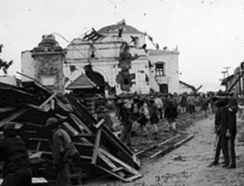
The 1917-1918 Guatemala Earthquakes
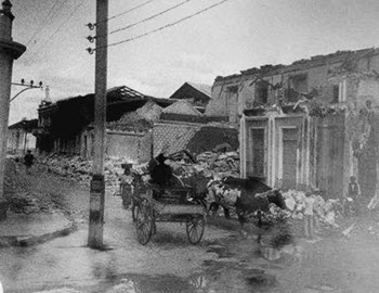 Rather than just one main event, this was a sequence of earthquakes that occurred from 17 November 1917 through 24 January 1918. Over time, the shakes grew stronger, causing more and more destruction. Some shakes were described as sideways shakes, while others moved the ground up and down.
One of the individual shakes that we know the most about was the one that occurred on Christmas Day. It reached the magnitude 5.6 and had its epicenter at 15.32°N 89.1°W in eastern Guatemala.
Damage
When the earthquakes started in mid-November, several settlements around the town Amatitlán were severely damaged.
New strong earthquakes occurred on 25 December, 29 December, 3 January, and 24 of January. These quakes were strong enough to be felt in many different parts of the country, and they destroyed buildings in places such as Antigua Guatemala (the old capital city) and Ciudad de Guatemala (the current capital city). In Antigua Guatemala, several structures that had survived the 1773 quake now sustained serious damage.
With each new shake, additional buildings collapsed. Many of them had been weakened by previous shakes before they finally went down, with the walls collapsing and the roof falling in. Many different buildings were affected, including churches and bell towers. Some buildings were not damaged by the shake itself, but by the debris that came crashing down from structures collapsing nearby.
The continued shakes created many gruesome scenes. By the church La Merced in the capital, the earthquakes broke the tombs and mummified bodies fell out. The Guatemala City General Cemetery was completely destroyed in never fully restored. Approximately eight thousand bodies were shaken from their graves, and many of them were fresh enough to pose a medical threat. To prevent outbreaks of disease, city authorities burned the unearthed bodies in a massive bonfire.
For two months, the newspaper “Diario de Centro América” issued two papers a day detailing the damage, which was pretty impressive since the printing press itself was affected by the shakes and surrounded by rubble.
On 12 January 1918, an article in the French magazine L’Illustration reported that about 2,000 people had been killed and roughly 200,000 people had become homeless in Ciudad de Guatemala. The article was based on a report cabled out of Guatemala on New Year’s Eve 1917.
Aftermath
The recovery work took a long time.
City officials would paint a black cross on buildings that were deemed insecure and had to be torn down or repaired for safety reasons, but contemporary reports show that a bribe of some hundred dollars were sufficient to get the house officially listed as repaired, allowing the owners to leave the building as it was, without actually fixing the issue.
When Prince Wilhelm of Sweden visited Antigua Guatemala and Ciudad de Guatemala in 1920, there were still large amounts of ruins left, and the reports from his journey describes thick clouds of whirling dust making people ill. Only one in every three houses was occupied; the others were just ruins. Reports from 1920 also show that many (empty) tombs in Ciudad de Guatemala had been left open and that the main cemetery had not been restored.
Prince Wilhelm urged the world to send money and goods to Guatemala, and soon ships carrying donations began to arrive to Puerto Barrios. Instead of reaching the population, however, they were confiscated by the the president and his cronies. A lot of the supplies were sold to Honduras for a good profit.
President Manuel Estrada Cabrera’s brazen embezzlement of aid and his general failure to properly lead the relief and recovery efforts largely contributed to the end of his reign. He had been the president of Guatemala since 1898, and was overthrown on 14 April 1920.
The 1942 Guatemala earthquake
This 7.7 moment magnitude and 7.9 surface wave magnitude earthquake occured on 6 August, at 23:37 UTC time. Locally in Guatemala, this was at 17:37 in the evening of 6 August.
The epicenter was at 13.78°N 90.91°W, which is in the sea just off Guatemala’s Pacific coast.
The dept was 35 km.
The earthquake was strong enough to be felt in both Mexico and El Salvador.
Damage
38 fatalities were reported.
The worst hit zone was the west-central highlands of Guatemala.
In addition to the destruction caused by the shakings themselves, very destructive landslides were triggered which created additional damage. The heavy rains, typical of the season, contributed to the problem. Many roads and telegraph lines were damaged, making communications difficult. The Inter-American Highway was partly destroyed.
In Tecpán Guatemala, over 60% of the buildings became unhabitable.
In Antigua Guatemala, some high-profile constructions were damaged, including the Palacio de Los Capitanes Generales.
The 1976 Guatemala Earthquake
 With 23,000 reported fatalities and well over 75,000 injuries, this was one of the most catastrophic Central American earthquakes of the 20th century.
Not only did it have a magnitude of 7.5 Mw; it was also a very shallow-focused earthquake with a depth of just 5 km. Combined, these two factors made it a highly destructive force. As a comparison, the 7.9 Mw strong but 60 km deep earthquake of 1942 caused much less damage.
The 1976 Guatemala Earthquake occurred on 4 February at 03:01 local time, when most people were at home sleeping.
The epicenter was at 15.32°N 89.10°W, which is in the northeastern part of the country. The closest town was Las Amates in the Izabal department.
The maximum seismic intensity occurred in the Mixco area, in Gualán, and in some parts of Ciudad de Guatemala, where it reached IX on the Mercalli scale.
Ground shaking were felt for nearly 40 seconds.
Damage
Buildings in many different parts of Guatemala were damaged; not just in the epicentral zone. There were for instance reports of damages to buildings located in the capital city area, despite being some 160 km away from the epicenter.
Throughout the country, approximately 258,000 houses were destroyed and 1.2 million people lost their homes.
Visible rupturing occurred along more than 230 km of the Motagua fault. Average horizontal displacement along the Motagua fault was 100 cm, with a maximum displacement of 326 cm.
In some areas with high seismic intensity, the soil liquefied and sand boils could be seen.
The main shock was followed by thousands of aftershocks, including some large ones that caused addition destruction and even some fatalities. The main shock activated secondary fault zones, including the Mixco fault which is located in the densely populated zone just north-west of the capital.
In some parts of the country, it took days before electricity and phone service came back.
Relief work was made more difficult by the fact that 40% of Guatemala’s hospital infrastructure had been destroyed, and a substantial part of the remaining 60% had suffered damages. The numerous aftershocks were also a problem.
President Kjell Eugenio Laugerud García invited foreign ambassadors to tour the most heavily affected regions by helicopter, which in turn helped secure aid from numerous countries – including the United States, Canada and Belgium.
The 2007 Guatemala Earthquake
 This 6.7 Mw earthquake occurred on 13 June at 13:29 local time.
The epicenter was located at 13.55°N 90.62°E, which was in the Pacific Ocean, south of Puerto Quetzal. The distance to the capital was approximately 115 km.
The depth was 23 km. The maximal intensity was never more than VI (strong) on the Mercalli scale.
While earthquake was strong enough to be felt in neighboring El Salvador and parts of Mexico, it did not cause any damage there.
Damages
No fatalities reported.
A landslide occurred along the Inter-American Highway, but it was only a minor one.
A small number of houses were destroyed, and some additional ones damaged, along the southern coast.
The 2012 Guatemala Earthquake
This was a 7.4 Mw earthquake that occurred on 7 November at 16:35 UTC time. Locally in Guatemala, it was 10:35 in the forenoon.
The epicenter was at 13.987°N 91.965°W, which is in the Pacific Ocean, roughly 35 km south of Champerico, a port and beach town in the Retalhuleu department in southwestern Guatemala.
The maximum intensity was VII (very strong) on the Mercalli scale.
The depth was approximately 24 km.
Damage
With 39 confirmed deaths, this was the deadliest earthquake in Guatemala since 1976. Initially, the death toll was reported as 42, with 29 casualties reported from San Marcos, 11 from Quetzaltenango and two from Sololá.
Damage to buildings occurred in various part of the country, including the capital Ciudad de Guatemala and the second-largest city Quetzaltenango (Xelajú), as well as communities the departments San Marcos, Sololá, Quiché, Totonicapán, and Huehuetenango. Roughly 73,000 households lost electricity, and the Pan-American Highway was damaged. Official data from 11 November, a few days after the earthquake, lists 9,414 damaged houses and 18,755 evacuated individuals.
After the earthquake, the Guatemalan president declared a 30-day “state of calamity” for the most affected departments. It was subsequently prolonged to 25 July, 2013.
Outside Guatemala
Minor damage reported from Chiapas, Mexico. Telephone and internet services were interrupted.