Contents
Overview of Chalatenango
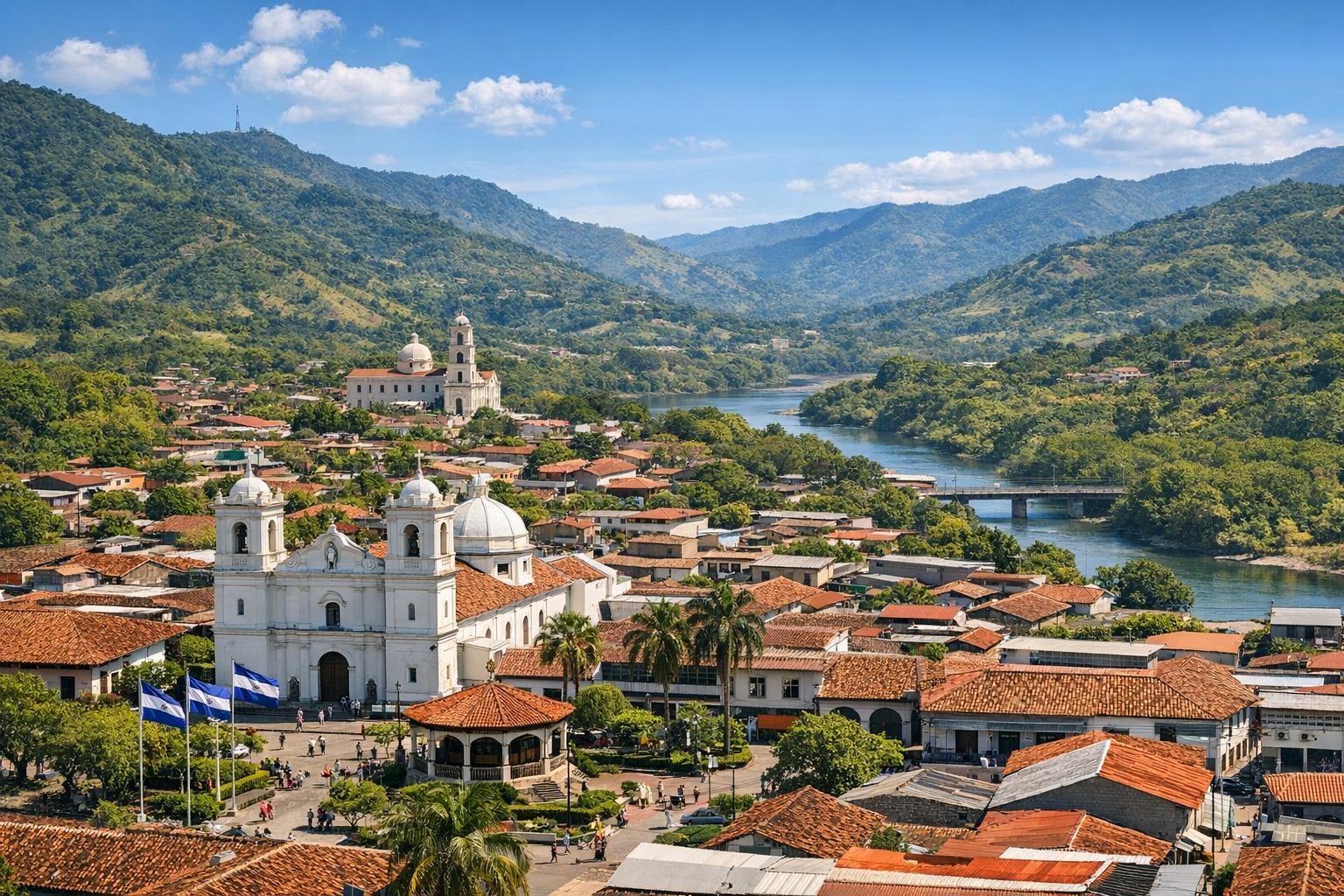
Chalatenango is a department located in the northern region of El Salvador, bordering Honduras and forming part of the country’s interior highland zone. It is recognized for its varied terrain, rural landscapes, and historical importance within both pre-Columbian and modern Salvadoran history. The department covers a large geographic area relative to its population density, resulting in a landscape where small communities are dispersed across mountainous terrain. Chalatenango serves as a transition zone between the central valleys of El Salvador and the more rugged northern highlands, and this position has influenced its economic patterns, cultural development, and infrastructure.
The name “Chalatenango” is believed to derive from the Nahuat language, often interpreted as “valley of sand” or “place of water and sand.” Indigenous groups inhabited the region long before Spanish colonization, and elements of indigenous heritage remain evident in local traditions, agricultural techniques, and place names. Over time, colonial settlement patterns introduced new administrative systems and agricultural practices that continue to influence the department today.
Geographical Features
Chalatenango is distinguished by its mountainous topography, with significant portions of its territory located within the Sierra Madre de Chiapas mountain range. Elevations vary considerably, creating microclimates across the department. These variations support a mixture of ecosystems, including cloud forests, pine forests, and river valleys.
The Lempa River, the longest river in El Salvador, passes through the department and is a critical natural feature. It provides water for irrigation, supports hydroelectric power generation in nearby regions, and contributes to local biodiversity. Smaller tributaries and streams are also common, especially during the rainy season, when water flow increases significantly.
The climate is generally classified as tropical, but altitude plays an important role in moderating temperatures. Higher elevations tend to be cooler and receive more precipitation, while lower valleys are warmer and experience more pronounced dry conditions. The wet season typically runs from May to October, while the dry season occurs between November and April. These seasonal patterns are essential for agriculture but can also contribute to challenges such as soil erosion and water scarcity.
The department’s natural environment offers opportunities for outdoor activities such as hiking, bird watching, and ecological tourism. Protected areas and forest reserves help conserve biodiversity, including species of birds, mammals, and plant life that are native to the region.
Municipalities and Administrative Divisions
Chalatenango is divided into multiple municipalities, each governed by local administrative bodies that coordinate public services, infrastructure, and community development. The department includes both densely populated towns and remote rural communities connected by a network of roads that vary in quality depending on location and elevation.
Chalatenango City, the departmental capital, serves as the primary administrative center. It hosts government offices, markets, and service providers that support surrounding municipalities. While relatively small compared to major Salvadoran cities, it plays a central role in regional commerce and governance.
Other municipalities, such as La Palma, El Pital, and San Ignacio, are known for their distinct local identities. La Palma, for example, has gained recognition for its artisanal traditions, particularly hand-painted crafts that are sold both domestically and internationally. San Ignacio and nearby areas have become focal points for tourism due to their proximity to highland attractions and scenic viewpoints.
Infrastructure development varies across the department, with urban centers having better access to paved roads, healthcare facilities, and educational institutions, while rural areas may face limitations in connectivity and public services. Efforts to improve infrastructure have been ongoing, supported by both national programs and international cooperation initiatives.
Economy and Livelihood
The economy of Chalatenango is largely based on agriculture, which remains the primary source of income for many residents. Maize and beans are staple crops cultivated for both subsistence and local markets. Coffee production is also significant, particularly in higher elevation zones where climatic conditions are suitable for coffee cultivation.
In addition to crop farming, livestock production contributes to the local economy. Cattle, poultry, and small-scale animal husbandry are common, providing meat, dairy products, and supplementary income for rural households. Agricultural practices often rely on traditional methods, though some farmers have adopted modern techniques to increase productivity and manage environmental challenges.
Remittances from Salvadorans living abroad play an important role in the economic stability of many families in Chalatenango. These financial contributions support household expenses, education, and small business development. Local markets and informal commerce also form an essential part of the economic landscape, with vendors selling agricultural products, textiles, and everyday goods.
Tourism is an emerging sector that complements traditional economic activities. Visitors are drawn to the department’s natural scenery, cooler climate in mountainous areas, and opportunities for outdoor recreation. Eco-tourism initiatives and community-based tourism projects have been developed to create sustainable income while preserving cultural and environmental resources.
Cultural Significance and Heritage
Chalatenango’s cultural heritage reflects a combination of indigenous traditions and Spanish colonial influences. Cultural practices are often expressed through festivals, crafts, music, and religious observances. Many communities celebrate patron saint festivals, which include processions, music performances, and communal gatherings.
Artisan traditions are particularly notable in certain municipalities. La Palma, for example, is recognized for its colorful painted wooden crafts, which depict rural life, landscapes, and symbolic motifs. These crafts have contributed to cultural identity and economic activity, attracting visitors and supporting local artisans.
Language and oral traditions also play a role in preserving heritage, although Spanish is the predominant language spoken today. Historical narratives related to the region’s role in national events, including periods of conflict, are passed down through generations and remain part of collective memory.
Religious practices, primarily influenced by Roman Catholicism and Evangelical Christianity, are central to community life. Churches and धार्मिक institutions often serve as gathering places and contribute to social cohesion within towns and villages.
Tourism is gradually developing in Chalatenango, with visitors attracted to its natural landscapes and cultural experiences. Initiatives that promote responsible travel and environmental conservation are becoming increasingly important as the region seeks to balance economic growth with sustainability.
Impact of Earthquakes and Seismic Activity
El Salvador is located within a seismically active region along the Pacific Ring of Fire, making earthquakes a recurring natural hazard throughout the country, including Chalatenango. The department’s mountainous terrain, combined with geological fault lines, increases its vulnerability to seismic events and related hazards such as landslides.
Historically, earthquakes have affected infrastructure, housing, and transportation networks in Chalatenango. Buildings constructed with traditional materials such as adobe are particularly susceptible to damage during seismic activity. In rural areas, where construction standards may be less regulated, the impact of earthquakes can be more severe, leading to displacement and economic disruption.
One of the most significant seismic events in recent Salvadoran history occurred in 2001, when a series of earthquakes caused widespread damage across the country. Chalatenango experienced structural damage to homes, schools, and public buildings. In mountainous zones, landslides triggered by ground shaking blocked roads and isolated communities, complicating relief efforts.
In response to such events, efforts have been made to improve building resilience and disaster preparedness. Government agencies and international organizations have supported programs aimed at promoting safer construction practices, early warning systems, and community-based emergency planning. These measures include training residents to respond to earthquakes and reinforcing critical infrastructure.
The department’s geography also means that seismic events can have long-term environmental consequences. Landslides can alter river courses, damage agricultural land, and increase erosion. Recovery efforts often involve not only rebuilding structures but also restoring livelihoods and stabilizing affected landscapes.
Public awareness of earthquake risks has increased over time, and educational campaigns have emphasized the importance of preparedness. Schools and community organizations frequently conduct drills and provide information on how to respond during and after seismic events.
Transportation and Connectivity
Transportation in Chalatenango is shaped by its terrain. Major roads connect the department to the rest of El Salvador, but travel within the region can be challenging due to winding mountain routes and varying road conditions. Public transportation options include buses and smaller vehicles that link municipalities and rural communities.
Efforts to improve road infrastructure have aimed to enhance connectivity, facilitate trade, and support tourism. However, maintenance remains an ongoing concern, particularly in areas affected by heavy rainfall or seismic activity. Improved connectivity is considered essential for economic development and access to services.
Environmental Considerations
Environmental management is an important aspect of life in Chalatenango. Deforestation, soil erosion, and water resource management are ongoing challenges that affect agriculture and community well-being. Conservation efforts focus on protecting forested areas, promoting sustainable farming practices, and preserving biodiversity.
Climate change has introduced additional uncertainties, including variations in rainfall patterns and increased frequency of extreme weather events. These factors, combined with seismic risks, require integrated approaches to planning and development that consider both environmental sustainability and disaster resilience.
Education and Community Development
Education plays a key role in the development of Chalatenango. Schools are present in most municipalities, though access may be limited in remote areas. Programs aimed at improving literacy, vocational training, and technical skills are part of broader efforts to enhance economic opportunities.
Community development initiatives often involve partnerships between local governments, non-governmental organizations, and international agencies. These initiatives address infrastructure, healthcare, education, and disaster preparedness, contributing to gradual improvements in quality of life.
For additional insights into travel opportunities and regional information, resources such as El Salvador Travel and Visit Centroamérica provide updated guidance on destinations and cultural highlights within Chalatenango and surrounding areas.