Contents
Geographical Overview
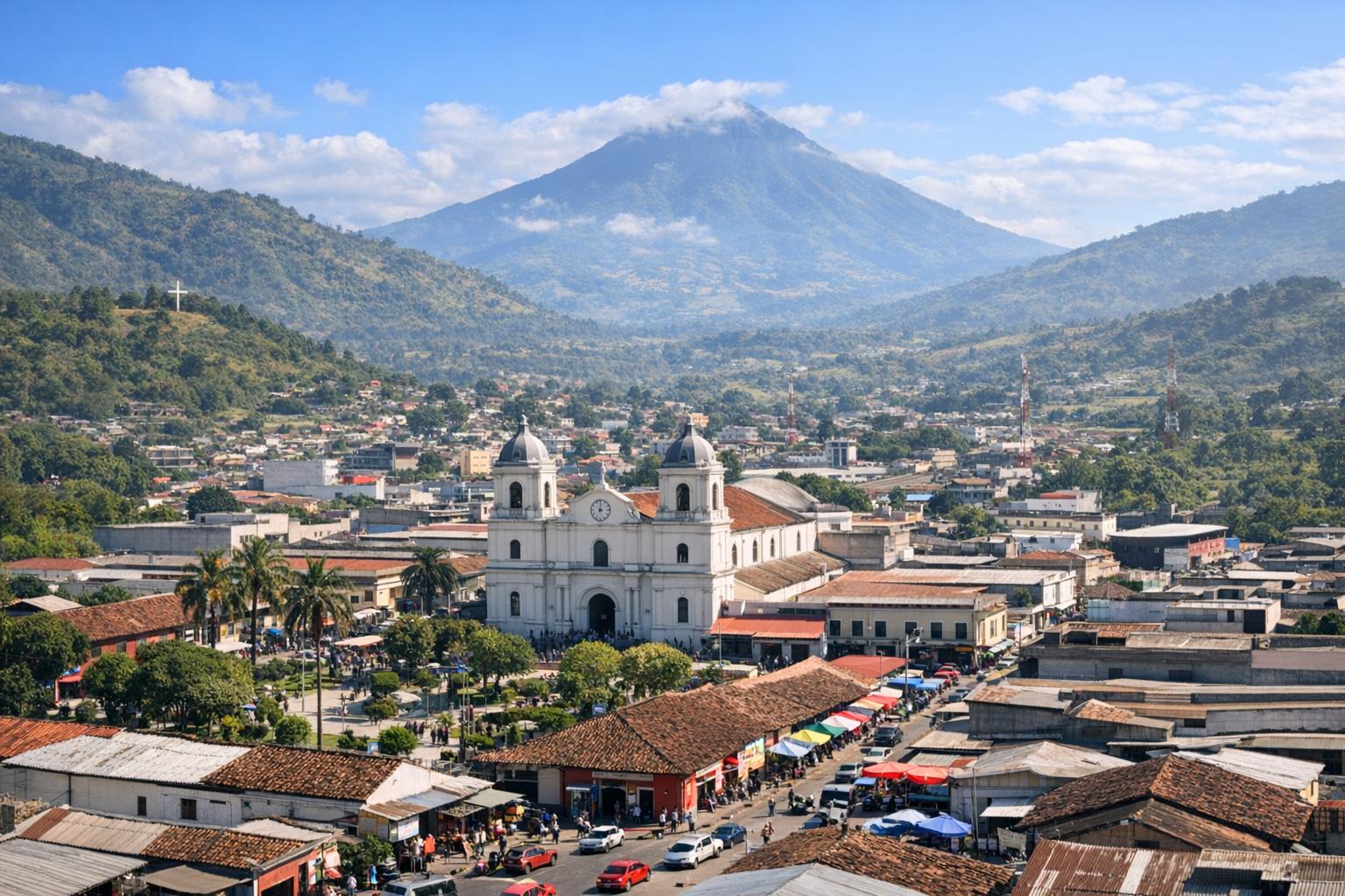
Jalapa is one of the 22 departments of Guatemala, situated in the southeastern portion of the country, where it forms a transitional zone between the central highlands and the lower eastern regions. It shares borders with the departments of Chiquimula to the east, Zacapa to the northeast, El Progreso to the north, Guatemala to the northwest, and Santa Rosa to the southwest. Covering an area of approximately 2,063 square kilometers, Jalapa presents a geographically varied territory shaped by volcanic formations, rolling hills, river valleys, and agricultural plains.
The department lies within a region influenced by the broader Central American mountain system, and its terrain is defined by a combination of elevations that range from moderate to high altitudes. This variation contributes to distinct local environments within relatively short distances. Valleys serve as centers of human settlement and agriculture, while elevated zones often retain forest cover or are used for pasture. Rivers and small streams crisscross the department, providing water resources essential for both domestic and agricultural use.
Geologically, Jalapa is part of a seismically active region, as Guatemala sits along the boundary of the Caribbean and Cocos tectonic plates. Although Jalapa is not directly on a major fault line like some western areas of the country, it is still affected by seismic activity that originates from regional tectonic movement. Over time, minor to moderate earthquakes have been recorded in and around the department. These seismic events have influenced construction practices, particularly in rural areas where traditional materials may be more vulnerable to damage.
Climate and Environment
The climate of Jalapa varies depending on altitude and topographical features, producing a range of microclimates within the department. Broadly, the region experiences a humid subtropical climate, with a distinct wet season typically extending from May to October and a dry season from November to April. Rainfall patterns are influenced by both elevation and prevailing wind systems, leading to differences in precipitation levels across the department.
Higher elevations tend to experience cooler temperatures throughout the year, with occasional mist and increased humidity supporting cloud forest ecosystems in certain areas. In contrast, lower valleys can become significantly warmer, particularly during the dry season, when temperatures may rise and water availability becomes a concern. These climatic variations support a diverse array of plant and animal life, contributing to the department’s ecological richness.
Jalapa’s natural vegetation includes pine and oak forests in elevated zones, as well as shrublands and grasslands in lower, drier areas. Agricultural expansion has modified some of these landscapes, yet pockets of native vegetation remain important for biodiversity. Bird species, small mammals, and insects adapted to both forested and open environments can be found throughout the region.
Environmental management has become increasingly important as population growth and agricultural demands place pressure on land and water resources. Local initiatives, sometimes supported by national institutions or international cooperation, aim to promote sustainable farming practices and conservation. Information about broader environmental efforts in Guatemala can be explored through resources such as Guatemala’s Ministry of Environment and Natural Resources.
Seismic activity also interacts with environmental conditions. Earthquakes, even when moderate, can trigger landslides in steeper areas, particularly during the rainy season when soils are saturated. These events can temporarily alter landscapes, affect river courses, and disrupt ecosystems, highlighting the dynamic interaction between geology and environment in Jalapa.
Economy and Agriculture
The economy of Jalapa is largely based on agriculture, which serves as the primary livelihood for a significant portion of the population. The department’s fertile soils and varied climate zones support the cultivation of staple crops such as maize and beans, which are central to the local diet and cultural practices. Coffee is another important crop, particularly in higher elevations where temperature and rainfall conditions are favorable for its production.
Livestock farming also contributes to the economy, with cattle, poultry, and other animals raised for both local consumption and sale. In many communities, agricultural activity is carried out on small to medium-scale farms, often family-owned, where traditional methods coexist with more modern techniques.
Jalapa city, the departmental capital, functions as a commercial center where agricultural goods are traded and distributed. Markets in the city connect rural producers with regional buyers, facilitating the movement of goods both within the department and to other parts of Guatemala. Small-scale industries, including food processing and artisanal production, complement the agricultural base of the economy.
Infrastructure development has played a role in shaping economic activity. Roads linking Jalapa to neighboring departments enable the transportation of goods, though in some rural areas, access can still be limited, particularly during the rainy season. Earthquakes have occasionally impacted infrastructure, causing damage to roads, bridges, and buildings. While large-scale destruction has been less frequent compared to regions closer to major fault lines, past seismic events have underscored the need for resilient construction and maintenance.
Efforts to strengthen economic stability include diversification initiatives, improved agricultural practices, and investment in local markets. These developments aim to enhance productivity while reducing vulnerability to environmental and geological risks.
Cultural Insights
Jalapa’s cultural identity reflects a blend of indigenous heritage and Spanish colonial influence, resulting in traditions that are expressed through language, food, festivals, and daily life. While the indigenous population in Jalapa is smaller compared to some western departments, elements of indigenous culture remain visible in agricultural practices, culinary traditions, and local customs.
Festivals and religious celebrations form a central part of community life. These events often combine Catholic traditions introduced during the colonial period with local customs, creating distinctive expressions of cultural continuity. Music, dance, and traditional attire may be featured during such occasions, providing an opportunity for communities to preserve and transmit cultural knowledge.
Cuisine in Jalapa reflects its agricultural foundation. Dishes such as pepian, a rich stew made with meat and spices, and chuchitos, a type of tamale, are commonly prepared and enjoyed. Ingredients are typically sourced locally, reinforcing the link between food and the surrounding landscape.
Architecture in Jalapa includes a combination of colonial-era structures, modern buildings, and traditional homes constructed with local materials. In some areas, the impact of earthquakes has influenced architectural choices. Buildings may incorporate reinforced materials or design features intended to improve stability. Older structures, particularly those built before modern building standards were adopted, can be more vulnerable to seismic activity, and some have been damaged or altered following past earthquakes.
Cultural institutions and local organizations contribute to preserving heritage while adapting to contemporary conditions. Through education and community engagement, efforts are made to maintain traditions while addressing challenges associated with modernization and environmental change.
Tourism and Attractions
Tourism in Jalapa is characterized by a combination of natural landscapes, historical sites, and cultural experiences. While it is not among the most heavily visited departments in Guatemala, it offers a range of attractions that appeal to travelers seeking less crowded destinations.
The Monjas Ruins, an archaeological site located within the department, provide insight into pre-Columbian history and the region’s early inhabitants. Visitors interested in anthropology and archaeology often explore this site as part of a broader understanding of Guatemala’s ancient civilizations. Additional information about travel opportunities in the country is available at Guatemala’s official tourism platform.
Natural reserves and protected areas in Jalapa offer opportunities for hiking, bird-watching, and ecological observation. The department’s varied terrain allows visitors to experience different environments within a relatively compact area. Scenic viewpoints, forest trails, and river systems contribute to outdoor recreational activities.
Local markets and festivals also attract visitors who are interested in cultural experiences. These settings provide a direct view of everyday life, where agricultural products, handmade goods, and traditional foods are exchanged. Interaction with local communities can offer a deeper understanding of the department’s social and cultural dynamics.
Earthquakes have had an indirect influence on tourism by shaping infrastructure and preservation efforts. Historical structures that have survived seismic events are often considered part of the region’s heritage, while restoration projects aim to maintain their integrity. At the same time, awareness of seismic risk has led to improved safety measures in public spaces and accommodations.
In summary, Jalapa presents a multifaceted region where geography, climate, economy, and culture intersect. Its exposure to seismic activity, while not as pronounced as in other parts of Guatemala, remains an important factor in shaping infrastructure, environmental management, and community resilience.